Difference between revisions of "West Mountain"
| (6 intermediate revisions by the same user not shown) | |||
| Line 20: | Line 20: | ||
*[[Bio:Swart, Clifford H.|Swart, Clifford H.]], 1912-1997 | *[[Bio:Swart, Clifford H.|Swart, Clifford H.]], 1912-1997 | ||
*[[Bio:Tubbs, Fred family|Tubbs, Fred family]] | *[[Bio:Tubbs, Fred family|Tubbs, Fred family]] | ||
| + | *[[Messer Family]] | ||
| + | *[[Shultes Family]] | ||
==Schools== | ==Schools== | ||
| Line 62: | Line 64: | ||
Image:WestMtME web.JPG|<center>[[West Mountain Methodist-Episcopal Church]]</center> | Image:WestMtME web.JPG|<center>[[West Mountain Methodist-Episcopal Church]]</center> | ||
Image:Exterior.jpg|<center>[[West Mountain Methodist-Episcopal Church]]</center> | Image:Exterior.jpg|<center>[[West Mountain Methodist-Episcopal Church]]</center> | ||
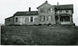
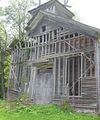
| − | Image:farmhouse 1.JPG|<center>An abandoned farmhouse on West Mountain from the 1930s. The Albany County Land reclamation project enticed many farmers to sell their land | + | Image:farmhouse 1.JPG|<center>An abandoned farmhouse on West Mountain from the 1930s. The Albany County Land reclamation project enticed many farmers to sell their land, photo by Arthur Rothstein </center> |
| − | Image:farmhouse 2.JPG|<center>An abandoned farmhouse on West Mountain from the 1930s. The Albany County Land reclamation project enticed many farmers to sell their land | + | Image:farmhouse 2.JPG|<center>An abandoned farmhouse on West Mountain from the 1930s. The Albany County Land reclamation project enticed many farmers to sell their land,photo by Arthur Rothstein</center> |
| − | Image:farmhouse 3.JPG|<center>An abandoned farmhouse on West Mountain from the 1930s. The Albany County Land reclamation project enticed many farmers to sell their land.</center> | + | Image:farmhouse 3.JPG|<center>An abandoned farmhouse on West Mountain from the 1930s. The Albany County Land reclamation project enticed many farmers to sell their land,photo by Arthur Rothstein</center> |
| + | Image:farmhouse 4.JPG|<center>Interior of abandoned farmhouse</center> | ||
| + | Image:farmhouse 4a.JPG|<center>Interior of abandoned farmhouse</center> | ||
| + | Image:laura 1.jpg|<center>July 1939-Doris Duell on the right and Deloris Duell 2 yrs old and Richard Duell, photo courtesy of Laura Casey</center> | ||
| + | Image:laura 7.jpg|<center>Francis Porter, in back, and my grandmother, Doris Duell Parker, 1937,photo courtesy of Laura Casey</center> | ||
Image:{filename}|<center>{caption}</center> | Image:{filename}|<center>{caption}</center> | ||
| + | Image:{filename}|<center>{caption}</center> | ||
| + | Image:{filename}|<center>{caption}</center> | ||
| + | Image:{filename}|<center>{caption}</center> | ||
| + | Image:{filename}|<center>{caption}</center> | ||
| + | Image:{filename}|<center>{caption}</center> | ||
| + | |||
</gallery> | </gallery> | ||
Latest revision as of 20:25, 3 March 2014
Location
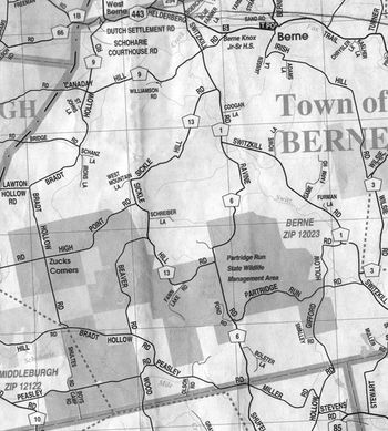
West Mountain refers to the highlands in the southwest quadrant of the town, and is the highest point in Albany County at 2,160 ft.
History
The 1787 Van Rensselaer lease map shows no one living on West Mountian. West Mountain was settled starting about 1790. Within a few years there were enough settlers to organize the Baptist Church of Christ, at Rensslaerville and Berne.
One of the early settlers was Samuel Taylor born 1766 in Portsmouth, RI.[1] At Rensselaerville, on September 25, 1799, Samuel Taylor died. He was 33 and left a wife and three children one of which was born an hour after his death. On September 27th a service was conducted at the house of the widow by Truman Beeman, Elder of the Baptist Church of Christ, at Rensslaerville and Berne. [2]
The Isaac Peasley family was also among the first settlers of West Mountain. Several generations of Peasley's were born and raised there and contributed to the community. Wallace A. Peasley was born on the family farm in 1857 as well as Orson his grandfather in 1805.[3] Wallace spent his life on West Mountain and was a breeder of through bred trotting horses. He was the owner of the famous stallion, Varrick, the subject of a Currier and Ives lithograph. Wallace continued to farm atop what is now referred to as "Peasley Hill" until the 1930's. His civil commitment included serving on the town Board of Supervisors in 1896 through at least 1899.
Most of the farms on West Mountain were bought by the Resettlement Administration in the 1930's. Many farms had already been abandoned due to repeated cropping with buckwheat, barley and rye. Soil erosion was commonplace.
Much of the land, up to 80% had been deforested for farming. Federal money was used to purchase the unproductive farmland for just 2 to 4 dollars per acre. The government helped to move many of the farm families to other areas. However, several farms remained in the possession of the farmers. A few of these included the William D. Wood farm, the Crosby farm, Peasley farm, and the Sherbin farm. Katie Wood, wife of William D. was approached by the Resettlement Administration during the 1930's and asked to sell her farm, to which as history tells, she answered with a solid 'No".
In the early 1940's, the Federal government granted the NYS Conservation Department a 99 year lease for what is now much of the Partridge Run Wildlife Management Area. The sum of $1.00 was the price for the lease, with three purposes stated for the land, forestry, wildlife and recreation. Over the next 20 years the total land accumulation through the Dept. of the Interior and the Division of Lands and Forests brought the total acreage to 5,478.
Families and Biographies
- Duell, Philo family
- Sellick, Peter family
- Shufelt, Ellery
- Swart, Clifford H., 1912-1997
- Tubbs, Fred family
- Messer Family
- Shultes Family
Schools
- Berne School No. 3 Peasley School, was located on Peasley Road across from the Baptist Church Cemetery. Established in early 1800's this school continued to operate through the 1930's. Lot 401
- District #13. Messer Lane and Corner of Ravine Road. Lot 450
- West Mt. School District No.19 West Mountain School was located near the Partridge Run Road on County Rt #6. It is unknown at this time when this District was established. It operated until the late 1930's early 40's when it was closed and the land bought by the USDA's Resettlement Administration under the Farm Security Administration of FDR. The school continued to stand until sometime before 1970 when it was torn down to widen the road. Lot 404
- District #20. Corner of Bradt Hollow Road and what was the extended Shultes Road. Lot 422
- District # 29 Lot 396
Businesses
Churches
Cemeteries
In the 19th and first couple of decades of the 20th Century, West Mountain was heavily settled. Here are some easily accessible historic cemeteries within or near the boundaries of Partridge Run that folks might want to visit while they are in the vicinity:
- Baptist Church Burying Ground - Seven Revolutionary War soldiers and a daughter of a Lord Mayor of London are buried here.
- Huntersland Christian Cemetery - Still an active cemetery, the earliest burial was 1844.
- Turner Burial Ground - The earliest known burial was 1812; last was 1937. It seems to have been a community burying ground from the beginning, as there are many different names of early farming families who lived in the immediate vicinity.
- West Mountain Methodist-Episcopal Church Cemetery - The earliest stone is dated 1816. The adjoining West Mountain Methodist-Episcopal Church flourished during the second half of the 19th century.
Additional Media
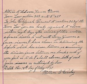
Notice to Choose Fence Viewer
Letter concerning a fence dispute. Contributed by Nichole Pelepzuk Cross.
Notice to Choose Fence Viewer.
Town Law section 363 ante P 639
To John Pelepzuck Persuant to section 363 of the Town Law you are hereby required to choose within eight days after service of this notice a fence viewer to act with Avery Zimmer a fence viewer I have chosen in determining the dispute which has arisen between us concerning the division fence between our lands; and if you fail to do I shall choose both of said fence viewers as authorized by law.
Dated this 18th day of May 1937
- Wallace A Peasley
Gallery
Fred Tubbs owned a farm on West Mountain, which is now part of Partridge Run, in the vicinity of Tubbs Pond;
from the collection of Martin Duell
Sources
- ↑ Berne Historical Project
- ↑ Peter Grant [email protected]
- ↑ his headstone in the Baptist Church Burying Ground: Orson Peasley died July 25 1886, aged 81 years 5 m's 3 d's.
