Difference between revisions of "Helderberg Hilltowns of Albany County, NY"
JElberfeld (talk | contribs) m (→Maps) |
JElberfeld (talk | contribs) m |
||
| Line 144: | Line 144: | ||
'''Sources and Notes''' | '''Sources and Notes''' | ||
<references /> | <references /> | ||
| − | + | ||
== '''[[Description]]''' == | == '''[[Description]]''' == | ||
== '''[[Maps]]''' == | == '''[[Maps]]''' == | ||
| − | [[Maps]] of the Hilltowns date back 250 years. | + | [[Maps]] of the Hilltowns date back 250 years. Click [[Maps|here]] for '''''[[Maps|more information]]'''''. |
== '''[[History]]''' == | == '''[[History]]''' == | ||
Revision as of 20:02, 26 September 2012

"The Helderberg Hilltowns" is a local term for the four towns, (Rensselaerville, Berne, Knox, and Westerlo,) in the hills of western Albany County, New York above the Helderberg Escarpment, the northern most part of the Allegheny Plateau.
"Below the hill" is a local term for the eastern half of Albany County below the Helderberg Escarpment. This land is in the Hudson River Valley.
HISTORY

Helderberg Hilltowns - an illustrated history will be available August 6 2012. Visit www.BeebeFarm.info to order signed copies with a dedication of your choice. See Pictures tell the stories of the four Helderberg Hilltowns from the July 12, 2012 Altamont Enterprise.
FORMATION OF THE HILL TOWNS
From 1790 - 1795 the four hill towns were one; all part of the newly formed Town of Rensselaerville.
NOTE: Click on the name of your favorite hill town to go directly there.
- Rensselaerville - formed in 1790 from part of the Town of Watervliet. At that time it included all of what are now the Towns of Berne, Knox, and Westerlo. In 1795 the northern part of the town became the new Town of Berne. Additional territory was taken from the eastern part of the town upon the formation of the Town of Westerlo in 1815.
- Berne - formed in 1795 from the northern part of Rensselaerville. In 1822 the northern half of the town became the new Town of Knox.
- Westerlo - formed in 1815 from the western part of the Town of Coeymans and eastern part of the Town of Rensselaerville.
- Knox - Knox was formed in 1822 from the northern half of Berne.
RENSSELAERWYCK
As the result of the 1609 voyage of exploration by Henry Hudson up the river that now bears his name, much of what is now New York State was claimed by the Dutch. In 1621 the Netherlands government granted the Dutch West India Company a 24-year trading monopoly in its American colonies. The Company conceived of the Patroon system as a way to attract settlers without increasing its expenses. A Patroon, or Dutch Lord, was granted a large tract of land; in return he agreed to sponsor settlers from the Netherlands and colonize the land at his own expense.
In 1629 Kiliaen Van Rensselaer, a prominent Amsterdam merchant and principal shareholder in the Dutch West India Company, was granted the right to purchase land from the Indians to create the Manor of Rensselaerswyck. It soon incorporated most of the land in what are now Albany, Rensselaer and Greene Counties. Fort Orange, now the city of Albany, just beyond the northeast corner of Rensselaerwyck, became the center of the Dutch fur trade.
The Dutch farmers were brought over by Van Rensselaer to clear and work land, but were not permitted to own it. Rather they were granted long-term leases, assuring the Patroon a healthy yearly income. The leases could be sold, along with the buildings built by the tenant farmers, but the underlying land and mineral rights belonged to the Patroon. When the English wrested control of the Dutch American colonies in 1664 they did not disturb the Patroon system.
In a few decades both sides of the Hudson River Valley were thickly settled with Dutch families. Each January the tenant farmers made the sometimes long trek to the Van Rensselaer manor house in Watervliet to pay their annual rent in produce and labor, typically four fat fowl, 24 bushels of good winter wheat, and a day's labor with horse and wagon.
SETTLEMENT ABOVE THE HELDERBERG ESCARPMENT
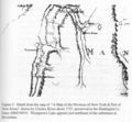
"A Map of the Province of New-York & Part of New Jersey" drawn by Charles Rivez about 1757. The Huntington Library, San Marino, California.<br.>Thompsons Lake is shown to the east of Beaverdam 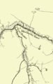
1772, Fox Creek, east branch of Schohary Creek. Mante, Thomas. "The History of the Late War in North America." London: 1772. (New York State Library, Albany, NY<br.>Schoharie with Beaverdam and Thompsons Lake in lower right quadrant; east west wagon trail to the north of Beaverdam goes through Knox 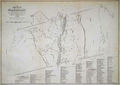
1767 Map of the Manor Renselaerwick - Bleeker, Surveyor - http://www.nysl.nysed.gov/mssc/vrm/images/map_bleeker_high.jpg 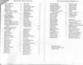
Christoph, Florence A. "Upstate New York in the 1760s: Tax Lists and Selected Militia Rolls of Old Albany County, 1760-1768." Camden, ME: Picton Press, 1992. p60.


Click on images to enlarge.
A 1767 survey map by John R. Bleeker of the entire Rensselaerwyck Manor, shows 133 lots on the west side of the Hudson River and 148 on the east side. An index on the map identifies the families that lived there. There are two clear leases above the Helderberg Escarpment in what is now the Town of Westerlo, one was to Koenard Hogteling and the other to Casper Fouser. In what is now the Town of Knox near the Schoharie County line, along the wagon road between Altamont and Schoharie, are two names, Hett? and Smith. To the east along the road are four other scattered houses with no names.
The area in what is now the Town of Berne shows a lake, but no houses, even though two years earlier there were enough people living at the Beaver Dam to organize the Dutch Reformed Church. Since the survey map covers the entire Manor, and gives the name of each person below the Helderberg Escarpment holding a lease, it is reasonable to assume that the only leases above the Escarpment at the time were as previously mentioned. The "Good Patroon," as the elderly Stephen Van Rensselar II was called, apparently had not had the individual homesteads surveyed nor issued leases to the perhaps half a hundred families who had been squatting on his mountain lands, some possibly for forty years.
Due to the lack of primary evidence, it is difficult to determine the names of the earliest families in the Helderbergs. The Palatines who initially settled in the greater Schoharie area were quite obstinate; they clearly did not put much store into paying rent or buying land; as a consequence, there are no early deeds or leases. Also, for several decades there was no church in the Helderbergs; marriages and baptisms were frequently performed by a circuit preacher and recorded in Schoharie or elsewhere. During this early period of settlement it appears that the Beaver Dam area was considered part of Schoharie; so naturally records indicate they lived there. For all of these reasons, it is impossible to say with certainty who were the first settlers in the Helderbergs, where they lived, or when they arrived. That being said, there is no doubt that the majority of the early settlers were German speakers, especially to in the western half, with a few Dutch settlers to the east above the Helderberg Escarpment.
In 1774 Catherine Van Rensselaer, the widow of Stephen Van Rensselaer II, a grandson of Kiliean, issued a lease to Jacob Weidman for land on Fox Creek in the Beaver Dam upon which Weidman had constructed the first sawmill and gristmill almost 20 years earlier. Surveys were also made for the homesteads of Peter Dietz and Conrad Swart in the Switzkill Valley, and leases signed by the Catherine Van Rensselaer.[1]. There were undoubtedly other leases issued about this time.
1787 VAN RENSSELAER SURVEY
Apparently during the war years no new leases were issued. Then about 1785, when Stephen Van Rensselaer III (1764-1839) reached his majority and inherited the family rights to the Manor, it became necessary to determine the extent of these land holdings. Job Gilbert and John E. and Evert Van Alen were hired to survey and map the entire Manor.
The 1787 survey map, by Wm. Cockburn is the culmination of the survey started perhaps in 1785. Although there had been the Bleeker survey in 1766 discussed above, the 1787 survey was the first complete systematic survey of the West Manor. The result was the leasing of existing farms to the homesteaders living on them, and the preparation for issuing leases of the vacant land as a means to expand the economic base of the Manor. The resulting survey map shows roads, churches, mills, and streams, gives the lot number and name of each leaseholder, and the acreage of each lot.
Most of the leases between the patroon of Rensselaerwyck and the tenants were generated between the late 1780s and the early 1800s. The terms of the lease usually stated that the tenant and his heirs agreed to hold title to the land in perpetuity and rent payments were to be made to the patroon annually in kind or cash. The leases also state the total acreage of land conveyed to the tenant along with the delineation of the plat. Releases of property to other individuals or parties is often documented. Lands described in these leases were situated in the East Manor and the West Manor.
The Manuscripts and Special Collections unit of the New York State Library owns an extensive collection of land records covering the Rensselaerwyck Manor, an area that once included large portions of Albany and Rensselaer counties. The Rensselaerwyck Manor Papers at the NYS Library has a partial index of some of the tenants and the lots they leased. There is much more information available at the Library itself.
- Click here for the full story of the 1787 survey map
- Click here for the 1787 survey map of the area that is now the town of Knox.
- Click here for the 1787 survey map of the area that is now the town of Berne.
- Click here for the 1787 survey map of the area that is now the town of Rensselaerville.
- Click here for the 1787 survey map of the area that is now the town of Westerlo.
Slavery
New York state laws regarding Negro Slavery.[2]
- The emancipation of slaves by the Quakers was legalized in 1798. At that date there were still about 33,000 slaves in the state.
- On March 29, 1799, an act was passed for the gradual abolition of slavery in New York. Any child
born of a slave after July 4th was to be free at the age of 25 if a girl and 28 if a boy.
- In 1817 an act was passed providing for the emancipation of all slaves in 1827 — 36 years before National Emancipation.
Anti-Rent War in the hilltowns
Click above to go to the Anti-Rent War page
Hill towns during the Civil War
Even though it was not a battleground, the Civil War had a devastating effect on the hill towns. Hundreds of men from the hill towns volunteered to join the Union army and sacrificed the life or limbs in a cause in which they fervently believed. Click for Detals.
1869 Harper's New Monthly Magazine

In 1869, Harper's New Monthly Magazine published a 16 page article on The Helderbergs. Future write-ups on the Helderbergs often borrow information from the article.
FOR VISITORS
"One of the greatest assets of the Helderberg Escarpment region is its attractiveness for outdoor recreational use. Its scenic vistas and natural surroundings provide the environment for a number of recreational activities."[3]
Upcoming events
- Upcoming events for visitors who want to know what is coming up when they "Head for the Hills."
- Upcoming Events of Special Interest to Hill Town Residents.
Those who wish to post upcoming events on these pages are urged to do so themselves.
Past events
- Researching Your Hilltown Ancestors - September 25, 2010 - Octagon Barn, Knox, NY
- HHA promotes local history and products - October 17, 2010 - Berne Fire Department Roast Beef Dinner, Berne, NY
Visitor attractions and facilities
To make it easier for visitors who want to "Head for the Hills," their are now separate pages of visitor attractions and facilities for each of the hilltowns:
- Berne visitor attractions and facilities.
- Knox visitor attractions and facilities.
- Westerlo visitor attractions and facilities.
- Rensselaerville visitor attractions and facilities.
And for those who like to hike:
Local maps
Laura DeGaetano, Natural Resource Planner, Albany County Department of Economic Development, Conservation & Planning, has provided links to the following resources published by her office:
- Albany County Bounty map - a resource map of Albany County farms and farm products.
- Discover the Helderberg Hilltowns map - a map showing the location of Helderberg Hilltowns farms and farm related businesses. It also has suggested tour routes.
Hard copies of the maps are available at her office, 112 State St. Room 720, Albany, NY 12207; Tel. (518) 447-5670.
- A Guide to Altamont and the Helderbergs published last year.
FOR FUN
- Then and Now - a series of images of buildings and locations in the Hilltowns comparing and old photo with a current image of the same scene.
[ Berne ] [ Knox ] [ Westerlo ] [ Rensseleaerville ]
- Antique Motor Vehicles - identify the make, model, and year of the the old vehicles.
- Helderberg Landscapes - showing the beauty of the Albany hill towns.
FOR HILL TOWNERS
Helderberg Hilltowns Association
Helderberg Hilltowns Association - promoting the economic development of the Helderberg Hilltowns
General ideas for towns, farms and other businesses
To move towards these goals, this site is encouraging visitors to Head for the Hills - the Helderberg Hilltowns as an inexpensive and close-by alternative to New England. Visitors will spend money, and thus boost the local economy and hopefully slow development and subdivision of farm land.
Upcoming events
- Upcoming Events of Special Interest to Hill Town Residents
- Upcoming events for visitors who want to know what is coming up when they "Head for the Hills."
Promoting the hill towns
Proposals to promote the hill towns has ideas for towns, farmers, and other businesses to promote themselves to folks from below the Helderbergs who want to visit the hill towns.
Specific proposals
Here are farther suggestions for farmers and businesses: [ Berne ] [ Knox ] [ Westerlo ] [ Rensselaerville ]
External Links
Further research
Rensselaerwyck Manor Papers in the NYS Library, Albany.
Albany Hilltown Companion sites
- Helderberg Hilltowns - a blog to keep people up to date on the latest activities and postings on this site. It is an alternative for folks who do not want to join Facebook.
- Albany County Hilltowns - A Facebook group is for folks interested in:
- - History of the hill towns of Albany County and the people who lived there.
- - Historic building preservation in the hamlets and countryside of the hill towns.
- - Preservation of the farmland and scenic beauty.
- - Promoting farms and farm activities.is a place for discussions this site and to keep informed of new developments on this site.
You don't have to be a member of FaceBook to visit the site and see what is happening. It is safe to visit.
- Head for the Hills - the Helderberg Hilltowns - a Facebook group dedicated to encouraging folks to visit the four Albany hill towns. You don't have to be a member of FaceBook to visit the site and see where we are headed.
Sources and Notes
- ↑ The 1787 survey map shows that it was Lot 518 that was leased by Conrad Swart in 1774. Adam Dietz, Jr. was on Lot 519 having taken over the farm of the deceased Peter Dietz.
- ↑ Altamont Enterprise, 8 May 1953
- ↑ Helderberg Escarpment Planning Guide
Description
Maps
Maps of the Hilltowns date back 250 years. Click here for more information.
History
Town sites have many links to local histories. Other reference books cover the entire Hilltowns. Click here for more information.
Military History
Family Histories and Genealogy
Farms and Lots
Historic Homes
Churches
Cemeteries
Schools
Organizations
Regional organizations include: