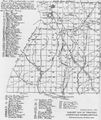
1787 map of Rensselaerville

About 1785 Stephen Van Rensselaer III hired William Cockburn to make a comprehensive survey of his Helderberg wilderness in preparation for leasing the vancant land in the hills surrounding the already settled valleys. The resulting 1787 survey map shows roads, churches, mills, and streams, gives the lot number and name of each leaseholder.
DIGITAL IMAGES OF THE 1787 MAP
The northern 1787 Wm. Cockburn map of the Western Manor of Van Rensselaer covers all of what are now the Towns of Berne and Knox. The southern map is of Rensselaerville and Westerlo. The maps are from photostats made in the 1930s or 40s of the original map in the NYS Library Manuscripts and Special Collections Division in Albany. These digital images were made by Harold Miller of photos taken of the photostat copies and manipulated in an attempt to sharpen the images.
The map below was reproduced from a book by Mrs. Washbon and was taken from From People Made it Happen Here, History of the Town of Rensselaerville, courtesy of the Rensselaerville Historical Society. It is based on the Cockburn Survey in 1787 for Stephen Van Rensselaer III. It shows the names of the inhabitants and the number of the lot on which their residences were located or on which they had made improvements without dwellings.

Key - Lot numbers on the key are the same as on the individual map sheets. 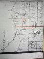
sheet SW2 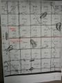
sheet SW3 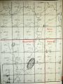
sheet SE1 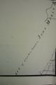
sheet SW4 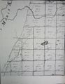
sheet SW5 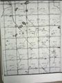
sheet SW6 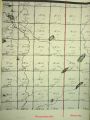
sheet SE4 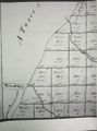
sheet SW7 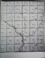
sheet SW8 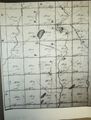
sheet SW9 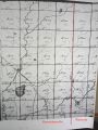
sheet SE7 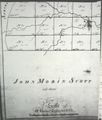
sheet SW10 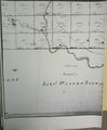
sheet SW11 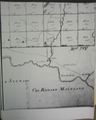
sheet SW12


Lot numbers and names as written
- Lot 5 Jeremiah Young
- Lot 6 Jeremiah Young
- Lot 7 Peter Plank
- Lot 8 Peter West
- Lot 9 Charles Edwards
- Lot 11 Gershon Stephens
- Lot 24 Hendrich Young
- Lot 24Peter Shoemaker
- Lot 26 Peter Becker
- Lot 37 William Shoemaker
- Lot 43 Peter Emerick
- Lot 45 Peter Bulson
- Lot 47 John Ellis
- Lot 55 Peter Miller
- Lot 66 Bastian Smith
- Lot 70 Samuel Howe
- Lot 84 Andries Huyck
- Lot 88 Curtis Cleveland
- Lot 89 Wifre Pence
- Lot 90 Ablel Mudge
- Lot 92 Johannis Hagahorn
- Lot 102 Peter Huyck
- Lot 109 Sylvester Peirce
- Lot 111 Daniel Cooper
- Lot 125 Abner Tremain
- Lot 127 Cabet Peirce
- Lot 126 no name given
- Lot 131 Daniel Cooper
- Lot 145 Thomas Farrington
- Lot 147 Samuel Martin
- Lot 147 Josiah Skinner
- Lot 148 Daniel Mudge
- Lot 149 George Van Bensen
- Lot 167 Levi Iren
- Lot 168 John Coons
- Lot 170 Jonathan Skinner
- Lot 181 W.P. Bela Phelps
- Lot 186 Thomas Brown
- Lot 186 Adam Coons
- Lot 186 Niel Mc Falls
- Lot 188 Reuben Burnpis
- Lot 188 Philemon Lee
- Lot 188 Hezekiah Dibble
- Lot 204 Hendrick Rhoda
- Lot 204 Samuel Nichols
- Lot 206 Ganabiel Palmer
- Lot 207 John Nichols
- Lot 209 Reuben Burnpis
- Lot 210 Bela Cook
- Lot 223 Jonathan Edwards
- Lot 224 Alanson Saxton
- Lot 224 Andrias Asher
- Lot 225 Andrias Asher
- Lot 225 Michael Brant
- Lot 225 Ashbel Culver
- Lot 226 John Rascana
- Lot 227 Nathan Hitch
- Lot 227 Jonathan Croker
- Lot 243 Widow Beers
- Lot 247 Daniel Coops
- Lot 262 ----- Berks
- Lot 262 ---- Stagts
- Lot 263 James Burthies
- Lot 266
- Lot 267 Joseph Lincoln
- Lot 267 John Ransier
- Lot 281 E. P.James Bryce
- Lot 282 John Keron
- Lot 283 John Hunter
- Lot 284 no name given
- Lot 320 Samuel Ramsey
- Lot 303 John Hunter
- Lot 351 James Connell
Alphabetical list of names
- Asher, Andrias Lot 224
- Asher, Andrias Lot 225
- Brant, Michael Lot 225
- Becker, Peter Lot 26
- Beeks, Widow Lot 243
- Berks,---- Lot 262
- Brant, Michael Lot 225
- Brown, Thomas Lot 186
- Bryce, E. P. James Lot 281
- Bilson, Peter Lot 45
- Berks, ----- Lot 262
- Burnpis, Reuben Lot 209
- Burnpis, Reuben Lot 188
- Burthiel, James Lot 263
- Cleveland, Curtin Lot 88
- Connell, John Lot 351
- Cook, Bela Lot 210
- Coons, Adam Lot 186
- Coons, John Lot 168
- Cooper, Daniel Lot 111
- Cooper, Daniel Lot 131
- Coops, Daniel Lot 247
- Croker, Jonathan Lot 227
- Culver, Ashbel Lot 225
- Dibble, Hezekiah Lot 188
- Edwards, John Lot 223
- Edwards, Charles Lot 9
- Ellis, John Lot 47
- Emerick, Peter Lot 43
- Farrington, Thomas Lot 145
- Hatch, Nathan Lot 227
- Hagahorn, Johanis Lot 92
- Hitch, Nathan Lot 227
- Howe, Samuel Lot 70
- Hunter, John Lot 283
- Hunter, John Lot 303
- Hyuck, Andries Lot 84
- Huyck, Peter Lot 102
- Iren, Levi Lot 167
- Keron, John Lot 282
- Lee, Philemon Lot 188
- Lincoln, Joseph Lot 267
- Martin, Daniel Lot 147
- Mc Falls, Niel Lot 186
- Miller, Peter Lot 56
- Mudge, Daniel Lot 148
- Mudge, Abiel Lot 90
- Nichols, Samuel Lot 204
- Nichols, John Lot 207
- NO NAME GIVEN Lot 129
- NO NAME GIVEN Lot 284
- Palmer, Ganabiel Lot 206
- Peirce, Cabet Lot 127
- Peirce, John Lot 108
- Peirce, Sylvester Lot 109
- Pence, Wifre Lot 89
- Phelps, W. P. Bela Lot181
- Plank, Peter Lot 7
- Ramsey, Samuel Lot 302
- Ramsey, George Lot 350
- Rhoda, Hendrick Lot 204
- Ransier, John Lot 267
- Rascane, John Lot 226
- Rhoda, Hendrick Lot 204
- Saxton, Alanson Lot 224
- Shoemaker, Peter Lot 25
- Shoemaker, William Lot 37
- Skinner, Joshia Lot 147
- Skinner, Jonathan Lot 164
- Skinner, Jonathan Lot 170
- Smith, Bastian Lot 66
- Stagts,--- Lot 262
- Stephens, Gershon Lot 11
- Tremain, Abner Lot 125
- Van Benses, George Lot 149
- Van Dyke, Derick Lot 103
- West, Peter Lot 8
- Young, Hendrich Lot 24
- Young, Jeremiah Lot 5
- Young, Jeremiah Lot 6