Difference between revisions of "Maps"
Jump to navigation
Jump to search
JElberfeld (talk | contribs) m |
JElberfeld (talk | contribs) |
||
| Line 23: | Line 23: | ||
*Click here for a copy of [[Beers 1866 map of Knoxville]] (Close-up) | *Click here for a copy of [[Beers 1866 map of Knoxville]] (Close-up) | ||
*Click here for a copy of [[Beers 1866 map - Knoxville Business Directory]] (Close-up) | *Click here for a copy of [[Beers 1866 map - Knoxville Business Directory]] (Close-up) | ||
| − | *Click here an explanation of the [[1866 Beers map]]. | + | *Click here an explanation of the [[h:1866 Beers map|1866 Beers map]]. |
==[[Beers 1866 map Knox Closeup]]== | ==[[Beers 1866 map Knox Closeup]]== | ||
Revision as of 02:06, 4 October 2012

1787 Survey Map
About 1785 Stephen Van Rensselaer III hired William Cockburn to make a comprehensive survey of his Helderberg wilderness in preparation for leasing the vancant land in the hills surrounding the already settled valleys. The resulting 1787 survey map shows roads, churches, mills, and streams, gives the lot number and name of each leaseholder.
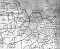
North west corner of Knox between Rt. 253 and Rt. 146 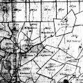
Knox central


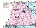
1854 map
Beers 1866 map of Knox
- Click here for a copy of Beers 1866 map of Knox
- Click here for a copy of Beers 1866 map of Knoxville (Close-up)
- Click here for a copy of Beers 1866 map - Knoxville Business Directory (Close-up)
- Click here an explanation of the 1866 Beers map.
Beers 1866 map Knox Closeup
Van Renssalaer Map 1877 tracing
Other maps
1866 map 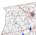
Knox Property Map 2008 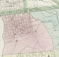
1829 map 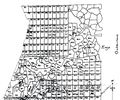
diagonal line on right is roughly the town line between Knox and Guilderland


Current maps
Here is a current map from MapQuest.