Beers 1866 map of Knox
Revision as of 00:37, 30 September 2012 by JElberfeld (talk | contribs) (Created page with "Image:KnoxMap1866.jpg<gallery>Image:KnoxMap1866FullDetails.jpg|<Center>1866 Beers Map of Knox - Detailed</center></gallery> <br> Full Title: Knox, Knoxville<br> Full Atlas Ti...")

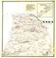
1866 Beers Map of Knox - Detailed

Full Title: Knox, Knoxville
Full Atlas Title: Albany and Schenectady Counties 1866
Country/Location: United States
Publish Date: 1866
Publisher: Stone & Stewart
Map Original Width: 14.19"
Map Original Height: 14.67"
A high resolution version can be viewed by going to the Guilderland Public Library site, http://www.guilpl.org/
Select Research, then Genealogy, and then Historic Map Works.
You must enter a valid library card barcode.
A search for Knox New York will bring up access to the map.
Click here for a more extensive explanation of the 1866 Beers map.
The farms are in order by Van Rensselaer Knox Lot numbers which tells approximately (and often precisely) which grid on Beers 1866 map of Knox the farm is located.