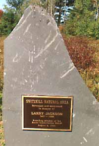
Switzkill Natural Area
Location
Switzkill Natural Area located on Sickle Hill Road in Berne.
Facilities
It has a walking trail which passes through a variety of habitats. It is a work in progress but is available to enjoy right now. Anyone interested in lending a hand on the next scheduled work day is invited to contact Terry Schwendeman at 872-2727 or Email: Terry Schwendeman
Switzkill Natural Area Report
The following is from the Switzkill Natural Area Report prepared by Larry Jackson in 1995 for the Berne Conservation Board:
Human Settlement
The Town of Berne was settled in 1750 by several Swiss families. A general account is given in Our Heritage, prepared by Berne Bicentennial commission as part of the 1976 bicentennial celebration. The Dietz and Ball families were the first to settle the Switzkill Valley. West Mountain was settled by the Schultes family which received a grant of 400 acres in 1787. The descendants of these families remain to this day, although the large grants have been subdivided and sold to newcomers. The current parcel was deeded to John Dunbar sometime prior to 1860. It subsequently was owned by Isaac Wilday (1861), James Wright (1895), Luther and Bessie Wright and Robie Jones (1929), Jessie and Robie Jones (1947), Leopold and Mary Salzer (1960), Keith and Joyce Harvey (19--), Anthony and Patricia Spadaro (1972) and finally by Katherine Baitsholts (1988).
ACQUISITION
In 1992, this tract of 32.9 acres was purchased for $32,000 by Iroquois Gas Transmission System and granted to the Town in conjunction with the construction of a natural gas transmission line through the Town. The gas line skirts the east side of the Switzkill Valley. Under the purchase / grant, the Town is obligated to retain this parcel as conservation land in perpetuity.
INVENTORY
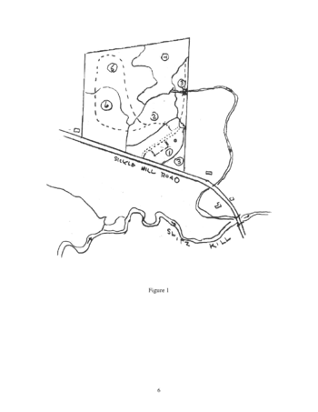
In order to develop a basis for managing this property, the Town needed a resource inventory. This inventory was completed by the Berne Conservation Board in the spring of 1992 and updated in 1994. It includes a documentation of the water resources; an impounded wetland and stream which flows into the Switzkill (Figure 1). Also included are soils which are taken from the Berne Soils Inventory completed by the Albany County Soil and Water Conservation District in 1980; and the flora and fauna surveys conducted in the spring of 1992. The location of cover types, drainage and presence of unique flora and fauna are the basis for the recommendations set forth below.
RECOMMENDATIONS
Since the Town’s mandate in accepting this property from the Iroquois Gas Transmission System is to retain it in conservation land, the following recommendations are toward that end. An additional requirement was that a sign be installed along Sickle Hill Road recognizing Iroquois as the benefactor.
1. An inventory of natural resources should be made and updated every 5 years as a basis for developing and revising the maintenance plan.
2. A sign should be installed along Sickle Hill Road; naming the area, giving the name of the Town and recognizing Iroquois Gas Transmission System as the grantor. This was accomplished in 1993. 3. A shale parking lot installed near the entrance of the area along the existing shale road, large enough to accommodate 10-12 cars (15’ X 35’). This was completed by the Town Highway Department in the fall of 1993.
4. A weatherproof kiosk be installed to store a register for users and an educational flyer. The kiosk was installed in the spring of 1994 along with an educational pamphlet rack. An educational flyer was developed in 1994 and a supply of pamphlets is in place in the rack. The register will be installed in the spring of 1995.
5. Develop and post on-site regulations. This was also accomplished by the Conservation Board in 1994.
6. Develop a trail system to allow visitors to see all six cover type units while reducing, to the extent possible, impact to the heron rookery. This trail will need to be raised in its entirety due to the wet nature of the ground, even in summer. Shale, covered by excelsior and bordered by logs, would probably work best. At least one bridge will be needed across the on-site stream (see Figure 1). A possible trail system which would minimize impact to the heron rookery is depicted by the dotted line in Figure 1. Installation of the trail is on hold pending an evaluation of use over the next few years. The register should prove helpful in this regard. Signs have been installed about 300 feet back from the heron rookery to warn users to stay out during the nesting season.
7. Long term maintenance:
- a) the access road and trails (if built) will require reshaling as needed in cooperation with the Town Highway Department.
- (b) signs and the kiosk should be kept in good repair and filled with supplies by the Berne Conservation Board.
- (c) the bridge and footpaths (if constructed) will need annual inspection and repair as necessary by the Berne Conservation Board and volunteers.
- (d) cover unit 1 should be mowed at least once annually to maintain the grass and forb cover. The Albany County Highway Department has agreed to do this when they mow along Sickle Hill Road in late summer. A member of the Berne Conservation Board will remind them in mid- summer.
- (e) Cover unit 2 will require removal of trees about every 5 years to retain a shrub cover and maintain visibility into the wetland proper. Trees can be cut by chain saw, piled as needed and stumps treated with an herbicide registered for wet areas. Work will be carried out under the supervision of the Berne Conservation Board by volunteers.

