Difference between revisions of "Maps"
Jump to navigation
Jump to search
JElberfeld (talk | contribs) m |
JElberfeld (talk | contribs) m |
||
| Line 16: | Line 16: | ||
==1787 Survey Map== | ==1787 Survey Map== | ||
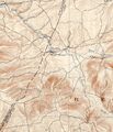
About 1785 Stephen Van Rensselaer III hired William Cockburn to make a comprehensive survey of his Helderberg wilderness in preparation for leasing the vancant land in the hills surrounding the already settled valleys. The resulting 1787 survey map shows roads, churches, mills, and streams, gives the lot number and name of each leaseholder. | About 1785 Stephen Van Rensselaer III hired William Cockburn to make a comprehensive survey of his Helderberg wilderness in preparation for leasing the vancant land in the hills surrounding the already settled valleys. The resulting 1787 survey map shows roads, churches, mills, and streams, gives the lot number and name of each leaseholder. | ||
| − | *[[h: | + | *[[h:1787 survey map|Click here for the full story of the 1787 survey map.]] |
*[[1787 map of Berne| Click here for 1787 survey map of Berne.]] | *[[1787 map of Berne| Click here for 1787 survey map of Berne.]] | ||
Revision as of 23:46, 30 September 2012

Contents
1757 map
1772 map
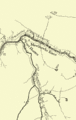
Schoharie Valley on the left with Beaverdam and Thompsons Lake in lower right quadrant; east west wagon trail to the north of Beaverdam goes through Knox<br.>(click to enlarge)

1787 Survey Map
About 1785 Stephen Van Rensselaer III hired William Cockburn to make a comprehensive survey of his Helderberg wilderness in preparation for leasing the vancant land in the hills surrounding the already settled valleys. The resulting 1787 survey map shows roads, churches, mills, and streams, gives the lot number and name of each leaseholder.
1854 map
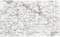
Beers 1866 map of Berne
Beers 1866 map of Berne from "New Topographical Atlas of the Counties of Albany and Schenectady, New York." Philadelphia: Stone & Stewart Pub., 1866 shows the family plots and family names as of 1866.
(click three times to enlarge) 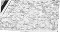
Beers map annotated with current road names


1900 Topographical Map
Switzkill Valley

1916 Farm map
Current maps
Here is a current map provided by MapQuest.
Sources